Sheung Luk Stream to Sai Wan Beach
- SamJackWebster

- Jul 29, 2020
- 4 min read
Updated: Jul 7, 2024
This adventure takes you along the entire length of Sheung Luk Stream, passing the famous Sai Kung Rock Pools and popular 20ft cliff jump. The stream then spits you out onto the white-sand beach of Sai Wan, where you can kickback with a beer and then catch a fast speed boat back to Sai Kung Town. Along the stream you'll come across one large waterfall that requires a basic level of scrambling, but apart from that this trail is never too technical and should be manageable for the average hiker.


Hike Location: New Territories, Sai Kung East Country Park
Hike Difficulty: Moderate (5/10)
Hike Length: 4 hours
High Distance: 8km
Elevation Gain: ~250m
Full Disclosure: There is one large waterfall (photo 23, below) that you will have to descend to complete this trail. The descent is relatively straightforward and does not require much upper body strength, nor any previous climbing experiences. However, if you're afraid of heights then this will definitely test you.
This trail begins at a well-known camping area within Sai Kung called Pak Tam Au. The nearest MTR station to Sai Kung Town is Hang Hau. Once you've made you way from Hang Hau to Sai Kung Town you then need to catch a taxi or double decker bus to the Pak Tam Au public toilet and bus stop (photos 1 + 2). All types of public transport regularly leave from the Sai Kung Public Pier.


From here, you simply follow the MacLehose Trail (Stage II) towards Chek Keng. This part of the trail is very straight forward and you'll reach Chek Keng after almost 3km.


Once you pass the wild cows and local restaurant of Chek Keng, take the right fork in the trail (photo 10). This rugged route will shortly lead you to the start of Sheung Luk Stream.


You'll hear the stream before you see it, and it'll appear on your left as you reach the fresh water collection pipes.


At this point you cross the stream for the first time with the path continuing on the opposite side. We did this hike during the summer months (aka the rainy season), but after a week with no rain, so the river system wasn't completely dry but it wasn't in full flow either.


This next section of the trail is quite tough as it covers two hundred-plus meters of exposed rocky incline. The river itself will be to your right although you might not see it for the next half hour or so. I'm sure you can follow the route from within the river, similar to many Hong Kong stream hikes, however I'm yet to attempt this so take care if you decide to venture in.


Keep following the signs to Sai Wan. The path will eventually turn into a set of steps that take you down into the stream. From here on, you'll be walking along side the river, or in it, until it empties out at the beach.


Eventually you'll come across a large dam (photo 20), at which point the path takes you through the bush and leads you to the top of a rather formidable looking waterfall.


This is the trickiest part of the hike. The easiest route down is marked with ribbons on the left side of the fall and really isn't that physically challenging (I've indicated the route with arrows in photo 23). However, I'd advise getting on all fours and taking the descent slowly, especially if it has rained within the week.


If the idea of climbing down this terrifies you, then I suggest looking for an alternative route down through the bush. Usually with hikes like this one there is an easier, but certainly more overgrown, path that takes you safely around the falls.
The three photos below are from another visit to this stream but after more rain.


Once you're at the bottom and have passed the first few pools, you'll begin a very blissful river walk with bamboo banks enclosing a body of clear bluish-green water. This will lead you to the famed 'Sai Kung Rock Pools'.


Through the bamboo archway and out to the rock pool and 20ft cliff jump. This deep pool is a true Hong Kong gem. You can expect to find people cooling off here most days of the year.


There is a series of large rock pools that follow on from the one with the cliff jump, leading right out to the white sands of Sai Wan Beach.


If the rock pools aren't motive enough to get you on this sweaty hike, then I'm sure the beach will be. Sai Wan Beach is a very secluded Hong Kong beach and subsequently has some of the clearest blue waters around.


As well as selling beers, the small beach restaurant is where you can purchase tickets for the fast speedboats back to Sai Kung Public Pier. When we were there in August, the last boat back was at 18:30 and we only just managed to grab the final two seats. I'd advise buying your ticket as soon as you get to the beach so that you aren't forced to walk to the nearest taxi pick up point (Sai Wan Pavillion, a further 2 kilometres over the hill).
Stay safe on the waterfalls, I hope you enjoy the trail!
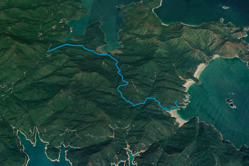
See the route I took on the MAP below (green dot is the starting point) and download the KML file to see the route in Google Earth 3D. Watch my KML tutorials for downloading the map on both laptop and mobile.


Below is a screenshot from the Google Earth KML file.


Comments