Ping Nam Stream
- SamJackWebster

- Jun 30, 2020
- 4 min read
Updated: Sep 7, 2021
Ping Nam Stream has everything. It takes you through Hong Kong's most Hawaii-like scenery, passing countless waterfalls, impressive cliff jumps, deep pools to swim in, clean running water and a ridge line to finish. Adding to its uniqueness, the trail ends up in a local market-garden village on the outskirts of Hong Kong, giving you a real sense of mainland rural China.


Hike Location: Nam Chung, North East New Territories
Hike Difficulty: Moderate (5/10)
Hike Length: 6 hours (allowing for plenty of non-moving time)
High Distance: approx. 10km
Elevation Gain: 414m
TIPS: On a hot weekend or a public holiday you'll likely cross paths with large canyoneering groups rappelling down the falls using ropes. If you're looking for a more peaceful hike then I'd recommend doing this one on a weekday
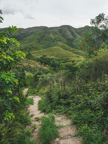
To reach the start of the trail, first head to Fanling MTR station. From there, take a taxi or minibus to Nam Chung Village (20 minutes drive) and get out at the intersection where there is a car park, small restaurant and public toilet. Start the hike by walking down the road in photo 1. If you're still unsure of where the hike starts, refer to the map attached at the bottom of the blog.


Walk along the road towards the hills for approx. 1 km until you reach another carpark and a blue fence. Follow the ribbons leading off to the right of the fence, hop the barrier and pass the danger sign (the HK sign signifying the start of an adventurous trail).


Follow the trail until you reach the mouth of the river system. Once surrounded by huge boulders, you need to head upstream.


The first thing to look out for is a small picturesque damn with a rope to the left of it (photo 10). We didn't need to use the rope on this occasion but its presence indicates how fast the river can flow. If you need it, you're in for a treat further on.


After the damn you'll find your first waterfall. It looks deep enough to jump off but its right at the start of the hike and it might be best to work up a sweat before fully immersing. Generally, plunge pool depth is proportional to waterfall height, but always test first-hand before taking the plunge.


Shortly after the first large waterfall, you'll come across a series of three more impressive falls and pools. They are all worth taking time to enjoy, although the fourth one is certainly the most fun (photo 15).


The water at the fourth fall is wide and deep and there are many jumping spots scattered around the pool. I tried climbing up a little higher in photo 19 as there were good hand-holds on the rock, but take care as it overhangs a little and the jump requires a good push out. We spent approx. 1 hour here.


After the pool with the rope, head back onto the trail to tackle the steep incline that works its way up and around the waterfall. Once you get to the top of the fall, take the right turn back down into the stream. You'll now be stood at the bottom of two more gradual-inclined falls. This is one of my favourite sections of the stream system as the rock formations make for great climbing.


Stick to the stream and enjoy the climb. It's never too physically demanding but at times requires some level of upper body strength. The river bed will soon plateau and you'll come across the Nam Chung Trail which crosses the stream for the first time. Avoid taking the path to the left and continue up the stream.


After some thick vegetation you'll arrive at an opening. The river bed will widen and most likely be dry apart from the deeper channels. I plan to do this hike again after heavy rain so I can witness this part of the stream in full flow. You can imagine from the photos how impressive this will be.


You're almost at the tallest cliff jump. Soon another dramatic waterfall rises above you (photo 28). You can jump from the top into the deep pool below, but since the jump is close to 30ft make sure you land in the middle of the pool. It will give you quite the adrenaline rush.


AND THEN... even more waterfalls. The falls yet to come are just as impressive, and the water appears even clearer and more inviting. Spend time swimming in these as you're nearing the end of the river system. The one I am bombing into is a favourite: the cave-like structure and the contrasts between the clear dark mountain water, vivid green leaves and crystal white falls creates a setting that does not feel like Hong Kong.


Stick to the stream, climbing over or around the remaining falls (usually to the right), until you reach a small concrete bridge. This is where the Nam Chung Trail crosses the stream for the second time and is where you'll turn off. Follow the trail towards Tan Chuk Hang.


After passing the sign on the Nam Chung Trail you'll confront a relentless set of steps that take you up and along the ridgeline.


From here on, follow the path for approx. 1 hour until you get to the next intersection. Continue straight and you'll soon see a stunning Shenzhen skyline in the distance and over the border into mainland China.


Eventually, after passing some hillside graves, you'll come out under the Nam Chung Country Trail Archway.


To finish, find your way through the very peaceful market-garden village until you reach Sha Tau Kok Road, from which you can catch a taxi or green minibus back to Fanling MTR.


Without a doubt, this is one of Hong Kong's most adventurous hikes, so take care and enjoy the climbing, swimming, jumping, jungle-trekking and stunning views.
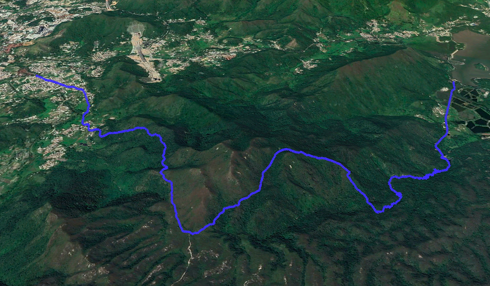
See the route I took on the MAP below (green dot is the starting point) and download the KML file to see the route in Google Earth 3D. Watch my KML tutorials for downloading the map on both laptop and mobile.


Below is a screenshot from the Google Earth KML file.


Comments