Bride's Pool
- SamJackWebster

- Jun 7, 2020
- 3 min read
Updated: Sep 7, 2021
This incredible waterfall trail is certainly up there with my Hong Kong favourites. DO THIS TRAIL AFTER HEAVY RAIN. Not only will you see the main falls of Brides Pool in all their glory but several other smaller falls along the way, and at one point you will need to traverse a knee-deep jungle river crossing. This is a stunning and secluded spot all year round. The easy 3 hour hike is surrounded by sub-tropical jungle from start to finish and is one of the best opportunities to enjoy Hong Kong's wild side.
Hike Location: New Territories, Plover Cove Country Park
Hike Difficulty: Easy (3/10)
Hike Length: 3 Hours
High Distance: 6-7km
Elevation Gain: 363m
TIPS: There is a large carpark at Tai Mei Tuk Tsuen if you'd prefer to drive.
The hike begins at the Pat Sin Leng Nature Trail archway (photo 3). To get there make your way to Tai Mei Tuk Tsuen in the New Territories. The nearest MTR stop is Tai Po Market, from which you can grab a taxi or minibus to Tai Mei Tuk Tsuen. Once at Tai Mei Tuk, walk to the very end of Ting Kok Road where it becomes Brides Pool Road (photos 1 + 2). Then follow the paved path up to the trailhead.
Once you reach the Pat Sin Leng trailhead, the route to Brides Pool is easy to follow. There are some intersections along the way but the direction to 'Brides Pool' is always obvious.
After the first hour or so you'll start to hear the water echoing in the valley below. From here on you can expect 3 to 4 river crossings, some of which will involve you getting wet after heavy rain. Others have paved bridges or can be crossed on dry stones. Take time to explore the river systems either side of the main route as I did in photos 7+8. If its flowing, you'll have fun scrambling up the waterfalls.
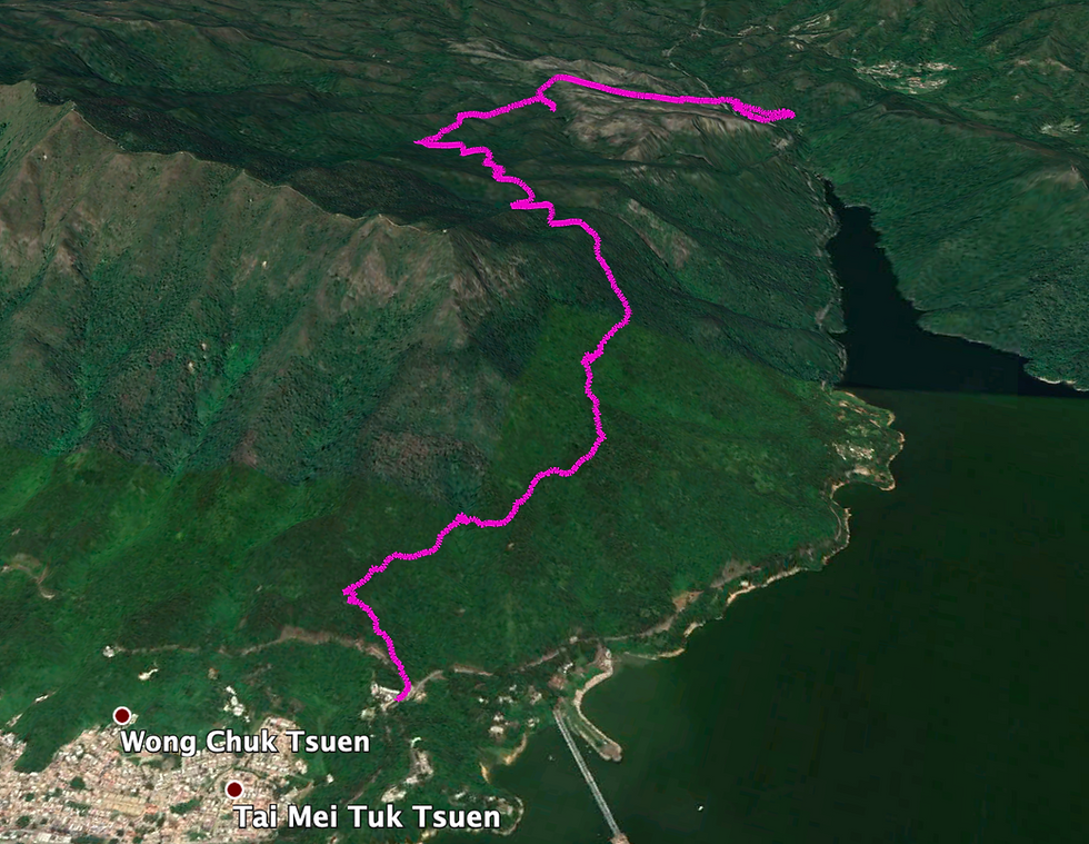
If you're following my route using the Google Earth KML file, then you'll notice I sidetrack from the main trail every now and then. This is just me exploring the river systems. As long as you follow the general direction of the trail you can't get lost and eventually you'll come out onto a road (photo 15).
Cross the road and you'll see the next trailhead to the left, signed to BRIDES POOL. Go under it and follow the path down to the river. At this point you'll hear the main Brides Pool falls to your right. Continue along the stone paved path until you reach the intersection in photo 19. Here, double back on yourself by taking the sharp right turn at the big tree. It's easy to miss this path since it's an unmarked turning off the main trail and doesn't look like a route to the legendary Pool.
After following the path for another 5 minutes you need to venture into the stream and scramble up and over the rocks to reach the bottom of Brides Pool. It's not difficult, although potentially quite slippery. Follow up-stream for 5 more minutes and you'll reach the plunge pool. Its deep enough for a swim although a little murky, however the best thing to do here is venture behind the falls. Enjoy!
Getting back to Tai Mei Tuk Tsuen or to Tai Po can be tricky. Make your way back to the road where there's a small parking lot. From here you can grab a green minibus (only on the weekend). If you're lucky there'll be a taxi parked near the bus stop and if not, you should probably call one. Otherwise it's a 3 mile walk back along Brides Pool Road to where you started, which can be incorporated into the hike if you're looking for that extra bit of fitness.
See the route I took on the MAP below (green dot is the starting point) and download the KML file to see the route in Google Earth 3D. Watch my KML tutorials for downloading the map on both laptop and mobile.
Below is a screenshot from the Google Earth KML file.


Comments