Ma On Shan to Sai Kung Ridge Trail
- SamJackWebster

- Oct 23, 2020
- 3 min read
Updated: Jan 12, 2025
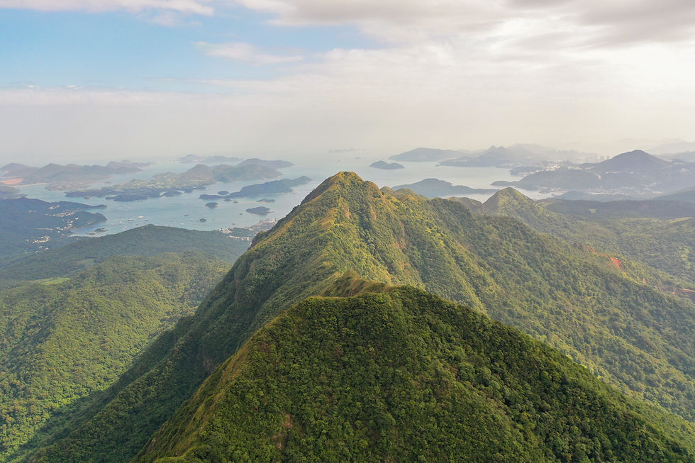
This is probably the most adventurous ridge trail on offer in Hong Kong. A steep ascent consisting of concrete steps, a muddy track and the occasional rope-assisted scramble, quickly brings you 700m above Ma On Shan town. Definitely choose a clear day for this hike; once on the ridge you have an epic split-panoramic view of rural Sai Kung to the east and bustling city life to the west. The 10km trail then finishes by bringing you down into Sai Kung Town where there are plenty of places to retreat for sunset bevs.
Hike Location: New Territories, Ma On Shan Country Park
Hike Difficulty: Moderate - Difficult (6/10)
Hike Length: 4-5 hours
High Distance: 10km
Elevation Gain: 735m
The start of this hike begins at the Ma On Shan Family Walk archway. The closest MTR stations are Ma On Shan or Heng On. From one of these, you then need to catch a taxi to Ma On Shan Tsuen Road which will take you into Ma On Shan Country Park. Refer to my maps at the bottom of the blog if still unsure where to find the archway.


The steps shortly take you to the start of an off-piste section marked by a 'danger' sign. Don't be put off, this is a well known trail and poses little risk. Just don't attempt it during a typhoon.


Stick to the muddy track and follow the danger signs if in doubt. Soon Ma On Shan Town will come into view behind you.


The first checkpoint is a large outcrop of rock that overlooks Shing Mun River and the Tolo Channel. This is great for climbing and gives you an opportunity to take in the scenery whilst catching your breath from that initial steep incline.


When you're ready, continue along the trail to approach the rope section. This is the only scrambly bit of the hike but is actually quite straight forward, and you have the rope if necessary.


After the ropes comes a tough ascent through thick forest, leading you to the top of Hong Kong's most epic ridge line. This is perhaps the most challenging part of the hike.


Upon reaching the top (although not the very highest point) you'll be presented with an incredible split-panoramic view; nothing but mountains, islands and ocean to the East and the lego towers of Ma On Shan to the west.


Walking along the ridgeline will then take you to the very top of Ma On Shan, marked by a trig point. From here, you should follow the clearly defined path down the south side of the mountain, heading towards Sai Kung Town.


On your way down, the Sai Kung scenery continues to impress. You'll also be faced with one last taxing ascent (Pyramid Hill) before descending back down upon a flat stretch of grass used as a run way for paragliders.


Continue along the path as it changes from grass to mud to concrete steps. After you've clocked a total of 10km you'll come out onto a road marked with arrows in the direction of Sai Kung Town. Referring to my maps if needed, you'll eventually reach the public pier where there are numerous places to grab a bite and a cold drink at sunset. Enjoy!
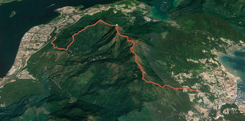
See the route I took on the MAP below (green dot is the starting point) and download the KML file to see the route in Google Earth 3D. Watch my KML tutorials for downloading the map on both laptop and mobile.


Below is a screenshot from the Google Earth KML file.


Comments