Castle Peak to Hong Kong's Grand Canyon
- SamJackWebster
- Jan 5, 2021
- 3 min read
Updated: Sep 7, 2021
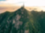
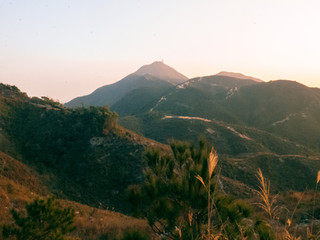
Castle Peak is a popular Hong Kong hike and in its shortest version is only a 2km walk along paved steps to the summit. I've therefore put together this challenging version of the trail that has the option of a steep, off-piste sketchy scramble section, followed by a deceptive trench-like track which guides you to Hong Kong's Grand Canyon. If you time this hike well, you'll be able to reach the mini-grand canyon for an atmospheric sunset with the silhouettes of Shenzhen and Macau visible across the South China Sea.
Hike Location: Tuen Mun, West New Territories
Hike Difficulty: Moderate-Difficult (6/10)
Hike Length: 3-4 hours
Hike Distance: 9km
Elevation Gain: ~650m
TIPS: A hiking pole and a torch may prove useful for the second half of the hike
The closest MTR station to the start of this hike is Tuen Mun. From here, head towards Tsing Shan Monastery Path, just off Yeung Tsing Road. This can be reached by a 20 minute walk from the MTR, or by taxi.


Once on the Monastery Path you'll pass a small temple and an archway. Continue along the road until you reach the paved steps and yellow railings. These railings will guide you up most of the way.


Follow the steps left, at the point depicted in photo 7, and then right at photo 8.


The steps are steep and unforgiving so you need to pace yourself. Take time to appreciate the views over Tuen Mun whilst catching your breath.


At roughly half way up, the paved concrete path turns into large stone steps; 5 minutes after this change there is a turn off into the trees and you can just about make out a lightly trodden route that meanders its way up towards the large rocks. This is where you should turn off if you fancy a thrilling rock climb.


Take care on the rocks as they drop off quite steeply (I would only recommend this section if you are a confident climber). Eventually the scramble route rejoins the main trail before bringing you to the pagoda at the top.


Just past the pagoda is a small lookout/exercise area that offers stunning views of Lantau Island and the South China Sea.

When you're ready, the trail continues to the right of the pagoda and you want to head towards the second, smaller radio station.


Once you past the second radio station you'll reach a trig point. This marks the start of a new challenge. The path below the trig point is VERY DECEPTIVE. From afar it looks like a simple clear-cut route, but the word 'trench' is certainly a better-fitting description.


Make sure to leave the trig point whilst you've got at least 1 hour of sunlight left; the pitted path can be slow going at times. You'll eventually reach a paved road which I'm sure will be a huge relief for some. If you follow this road up, you will finally arrive at Hong Kong's mini grand canyon.


Hopefully the weather will be on your side; when we hiked the sky was clear and an atmospheric sunset created a surreal setting unlike any I've experienced in Hong Kong before.


To get back to civilisation simply follow the road all the way back down to Sai Wan Court, this will take you anywhere between 30 minutes to an hour and will likely be in the dark so I suggest bringing a torch. From Sai Wan Court you can easily catch a taxi back to Tuen Mun MTR Station. I hope you enjoy this challenging version of Castle Peak!
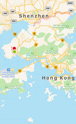
See the route I took on the MAP below (green dot is the starting point) and download the KML file to see the route in Google Earth 3D. Watch my KML tutorials for downloading the map on both laptop and mobile.


Below is a screenshot from the Google Earth KML file.
