High Junk Peak
- SamJackWebster

- Dec 12, 2020
- 2 min read
Updated: Sep 7, 2021
This is a non-strenuous hike that takes you to the top of a solitary peak overlooking the deep-blue waters of Clear Water Bay. Upon reaching the top you are rewarded with a stunning view of Sai Kung's scattering of islands. There are various lengths to this trail, however we finished up at Tin Hau Temple and clocked roughly 8km.
Hike Location: Sai Kung, Clear Water Bay Country Park
Hike Difficulty: Easy-Moderate (4/10)
Hike Length: 2-3 hours
High Distance: ~ 8km
Elevation Gain: ~400m
This hike begins directly opposite the Ng Fai Tin bus stop in Clear Water Bay. The easiest way to get there is by catching a train to Tseung Kwan O MTR station. From there you can then catch the 103M green minibus to the Ng Fai Tin bus stop. Look out for the Pagoda at the trail head.
Simply follow the steps until you reach a shaded dirt path. The path criss-crosses multiple times with a mountain bike route, but as long as you stick to the central track you can't get lost. This initial incline is definitely the toughest part of the hike, so if you can manage the hundreds of steps you'll find the remainder of the trail a breeze.
As the trail begins to plateau you'll reach an intersection. Continue straight, heading towards the open tree area. Don't take the right turn as this will lead you along a loop trail in the opposite direction to High Junk Peak.
Advancing through the trees will shortly lead you to an overgrown bamboo passageway. The canopy then opens up and you find yourself on an exposed ridge line with incredible views of Hong Kong's wild mountainous landscape dotted with the city's iconic concrete tower blocks.
Stick to the ridge line for another 5-10 minutes and the solitary peak will come into view. At the summit there's a trig point and a bunch of climbable rocks that make for great photos looking out over Clear Water Bay.
When you're ready, descend down the gravelly track on the south side of the peak.
At the base of the peak there is a trail crossroads with options to either head back to Clear Water Bay Road or to continue along the country trail. Sticking to the trail is what we did and will lead you to Tin Hau Temple via a very scenic route overlooking the bay and its neighbouring islands.
The trail then finishes when it descends down to Tai Au Mun Road. There's a bus stop 100m from where the trail comes out. Here the number 16 green minibus will take you back to Po Lam MTR station. If you have to wait a while for the bus then I recommend checking out the very atmospheric Tin Hau Temple. The temple sits on the waterfront with an incredible sunset view, so if possible try and time your hike to reach the temple for the end of the day. Enjoy!
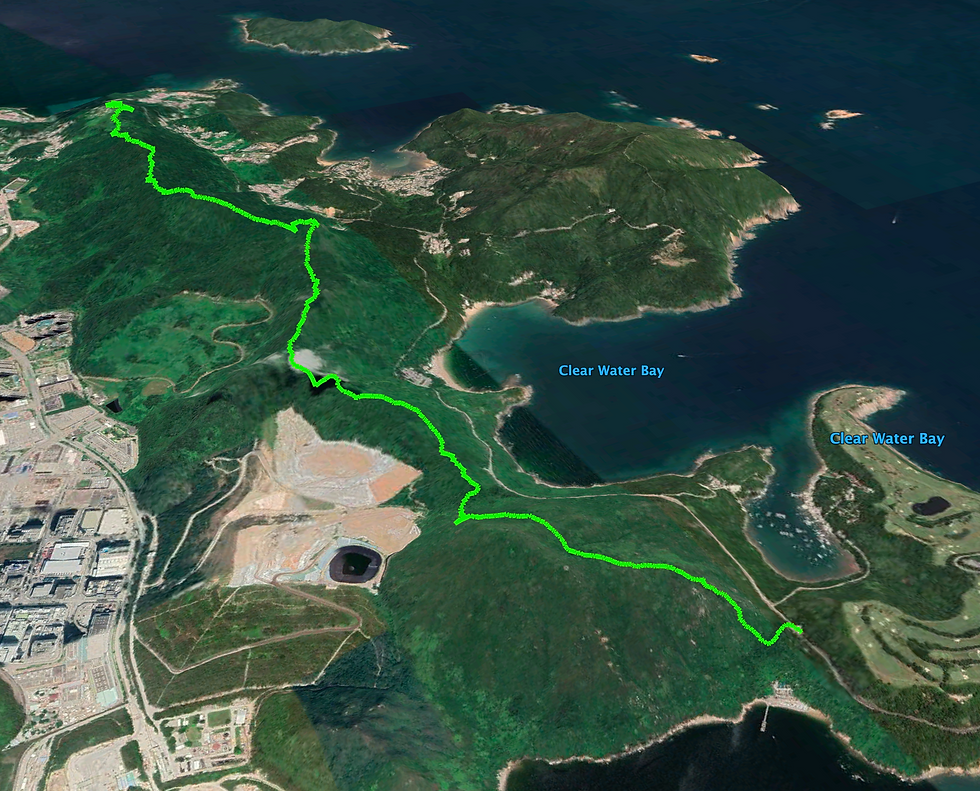
See the route I took on the MAP below (green dot is the starting point) and download the KML file to see the route in Google Earth 3D. Watch my KML tutorials for downloading the map on both laptop and mobile.
Below is a screenshot from the Google Earth KML file.


Comments