Hidden Dragon Stream
- SamJackWebster

- Jun 22, 2021
- 4 min read
Updated: Sep 7, 2021
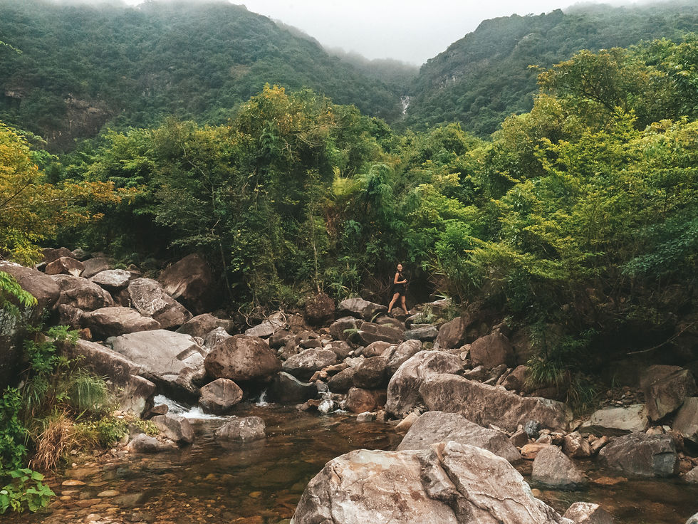
Hidden Dragon Stream is another spectacular series of waterfalls found within the Wong Lung Hang area behind Tung Chung. This tributary is one of many that run into the main Wong Lung Hang Stream. The Hidden Dragon waterfalls vary from gradually sloping to very vertical, with plenty of pools and climbing opportunities along the way. The water level reduces as you reach roughly 400m of elevation. At this point you continue to traverse the riverbed as it takes you through dense subtropical jungle until you reach a country trail near sunset peak; and thus, I'd recommend timing this hike for sunset.


Hike Location: Lantau Island, Tung Chung
Hike Difficulty: Difficult (7/10) - read 'Blog Difficulty Ratings Explained' on home page
Hike Length: 5-6 hours
Hike Distance: ~10km
Elevation Gain: ~700m
Tips: Give plenty of time to complete this hike, after lots of rain you should climb cautiously through the stream. You're aiming to reach Lin Fa Shan for sunset. After which you can decend down the forest steps to South Lantau Road and head towards Mui Wo.
Disclaimer: After multiple days of rain this riverbed becomes incredibly slippery, so stream-trekking-shoes are a must. There is one major section of this waterfall that requires lots of climbing and would be dangerous during the rainy months if you tackled it without the proper footwear. I don't remember seeing an alternative ribboned route, although this doesn't mean there isn't one, but I'm sure you'd regret having to turn around so close to the top.
To get to the start of the trail make your way to Tung Chung MTR station on Lantau Island. From here, get in a blue taxi and ask the driver to take you to "Wong Lung Hang Picnic Site". The taxi ride should only take 5-10 minutes. Simply follow the road up to the start of the stream.


Stick to the road for about 1km and note that the trail begins further along than the Wong Lung Hang Picnic Site itself. When you reach the fence at the end of the road, take the path to the left, which will lead you into the stream system.


Climb up the mossy steps under the trees on the left side of the water to bypass the dam structure, or take the ladder.


From here it should take approx. 30 minutes of in-stream hiking to reach the all important right turn.


This right turn (photo below) takes you into the Hidden Dragon tributary. When standing in the main stream and when the water is flowing well, if you look to the mountains ahead, you can actually see some of the Hidden Dragon waterfalls that you're about to tackle.
You will shortly reach the first large impressive falls and can climb up past it using the ropes on the right side.


Take care here. This first climb is one of the slipperiest sections of the hike, with a steep drop to your left. The ropes and tree roots provided strong hand-holds and were sufficient to get us up during June 2021. Still, give them a test first.


There's a nice pool on top if you already fancy a dip...


After this first pool there's a gradually sloping waterfall that can be hiked through, or along either side, using the drier rocks and small trees as aids.


At the top of this gradual falls is the next pool and large waterfall. Great photo opportunities here. It's basically a massive shower.


There are ribbons that take you up and to the right of the falls - this one is vertical and way too steep to climb.


The ribbons will bring you back down into the stream and place you at the bottom of the most challenging (and potentially dangerous) section. Here you're forced to tackle the incline via rock climbing. It's steep and can be VERY SLIPPERY; all dependent on the previous week's rainfall. Go slow and climb cautiously.


There was a short rope towards the top of the waterfall which seriously helped us on the last part of the climb. If it's still in place when you attempt this hike, use it at your own risk; never trust a rope you didn't tie with your entire body weight. Next time I do this hike I plan to replace it with something stronger.


Once you're up, look back and take in the views. It's such a surreal setting at the top of this tall waterfall, and quite the accomplishment to make it up. Here there is a lush big pool to sit in whilst looking out over the ridge lines of Lantau Country Park.


The pool and the huge boulder that sits beside it mark the start of the subtropical jungle section. The jungle section should take roughly 1 hour until you come out onto the Wong Lung Hang Country Trail.


As soon as you enter the jungle you'll see another steep waterfall ahead of you, this can be climbed to the left. Following this, you have a fare bit of in-stream hiking at a gradual incline, made slightly trickier by numerous fallen trees, until you finally reach the country trail.


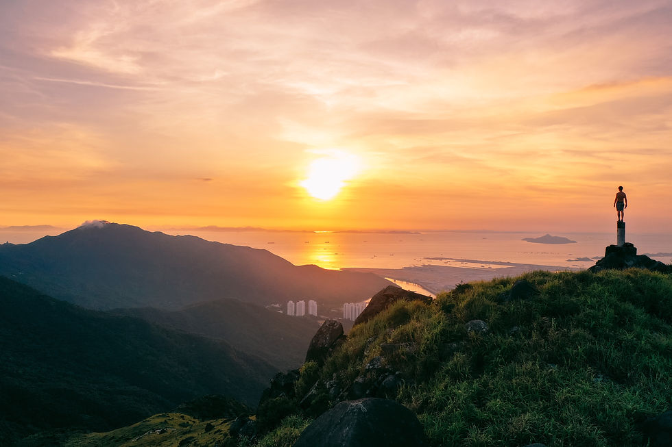
We finished this section during the dark which made for some great torch shots, however, I suggest aiming to finish whilst it's still light as the route up will be easier and you can catch the sunset over Lantau. When you reach the country trail, follow it left for roughly 30 minutes and you'll eventually arrive at the junction for Lin Fa Shan. There's no official sign post leading you to Lin Fa Shan, but it is the peak in the photos below.


If you've got the energy for a last little scramble then try and reach the trig point on Lin Fa Shan. In my opinion this is easily the best sunset spot on Lantau. You can then descend down the forest steps to South Lantau Road and head towards Mui Wo ferry pier for a beer. Enjoy!
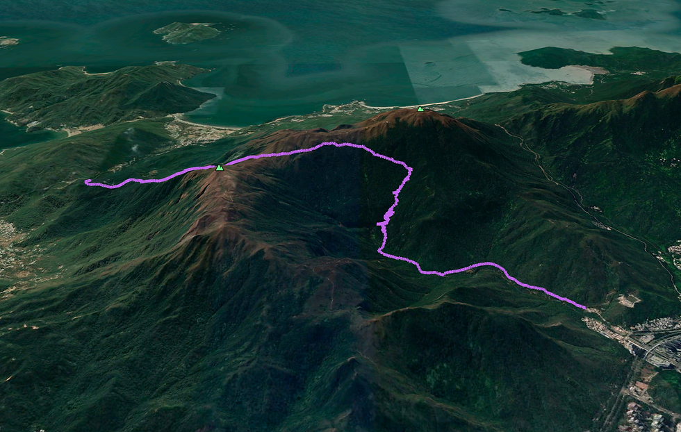
See the route I took on the MAP below (green dot is the starting point) and download the KML file to see the route in Google Earth 3D. Watch my KML tutorials for downloading the map on both laptop and mobile.


Below is a screenshot from the Google Earth KML file.


Comments